NASA Mars Rover's Weather Data Bolster Case for Brine
April 13, 2015

http://www.nasa.gov/jpl/msl/nasa-mars-rovers-weather-data-bolster-case-for-brine/
The Rover Environmental Monitoring Station (REMS) on NASA's Curiosity Mars rover includes temperature and humidity sensors mounted on the rover's mast. One of the REMS booms extends to the left from the mast in this view.
Image Credit:
NASA/JPL-Caltech/MSSS
Full image and caption:
http://www.nasa.gov/content/mars-weather-station-tools-on-rovers-mast
Martian weather and soil conditions that NASA's Curiosity rover has measured, together with a type of salt found in Martian soil, could put liquid brine in the soil at night.
Perchlorate identified in Martian soil by the Curiosity mission, and previously by NASA's Phoenix Mars Lander mission, has properties of absorbing water vapor from the atmosphere and lowering the freezing temperature of water. This has been proposed for years as a mechanism for possible existence of transient liquid brines at higher latitudes on modern Mars, despite the Red Planet's cold and dry conditions.
New calculations were based on more than a full Mars year of temperature and humidity measurements by Curiosity. They indicate that conditions at the rover's near-equatorial location were favorable for small quantities of brine to form during some nights throughout the year, drying out again after sunrise. Conditions should be even more favorable at higher latitudes, where colder temperatures and more water vapor can result in higher relative humidity more often.
"Liquid water is a requirement for life as we know it, and a target for Mars exploration missions," said the report's lead author, Javier Martin-Torres of the Spanish Research Council, Spain, and Lulea University of Technology, Sweden, and a member of Curiosity's science team. "Conditions near the surface of present-day Mars are hardly favorable for microbial life as we know it, but the possibility for liquid brines on Mars has wider implications for habitability and geological water-related processes."
The weather data in the report published today in Nature Geosciences come from the Cuirosity's Rover Environmental Monitoring Station (REMS), which was provided by Spain and includes a relative-humidity sensor and a ground-temperature sensor. NASA's Mars Science Laboratory Project is using Curiosity to investigate both ancient and modern environmental conditions in Mars' Gale Crater region. The report also draws on measurements of hydrogen in the ground by the rover's Dynamic Albedo of Neutrons (DAN) instrument, from Russia.
"We have not detected brines, but calculating the possibility that they might exist in Gale Crater during some nights testifies to the value of the round-the-clock and year-round measurements REMS is providing," said Curiosity Project Scientist Ashwin Vasavada of NASA's Jet Propulsion Laboratory, Pasadena, California, one of the new report's co-authors.
Curiosity is the first mission to measure relative humidity in the Martian atmosphere close to the surface and ground temperature through all times of day and all seasons of the Martian year. Relative humidity depends on the temperature of the air, as well as the amount of water vapor in it. Curiosity's measurements of relative humidity range from about five percent on summer afternoons to 100 percent on autumn and winter nights.
Air filling pores in the soil interacts with air just above the ground. When its relative humidity gets above a threshold level, salts can absorb enough water molecules to become dissolved in liquid, a process called deliquescence. Perchlorate salts are especially good at this. Since perchlorate has been identified both at near-polar and near-equatorial sites, it may be present in soils all over the planet.
Researchers using the High Resolution Imaging Science Experiment (HiRISE) camera on NASA's Mars Reconnaissance Orbiter have in recent years documented numerous sites on Mars where dark flows appear and extend on slopes during warm seasons. These features are called recurring slope lineae, or RSL. A leading hypothesis for how they occur involves brines formed by deliquesence.
"Gale Crater is one of the least likely places on Mars to have conditions for brines to form, compared to sites at higher latitudes or with more shading. So if brines can exist there, that strengthens the case they could form and persist even longer at many other locations, perhaps enough to explain RSL activity," said HiRISE Principal Investigator Alfred McEwen of the University of Arizona, Tucson, also a co-author of the new report.
In the 12 months following its August 2012 landing, Curiosity found evidence for ancient streambeds and a lakebed environment more than 3 billion years ago that offered conditions favorable for microbial life. Now, the rover is examining a layered mountain inside Gale Crater for evidence about how ancient environmental conditions evolved. JPL, a division of the California Institute of Technology in Pasadena, manages the Mars Science Laboratory and Mars Reconnaissance Projects for NASA's Science Mission Directorate, Washington.
For more information about Curiosity, visit:
http://www.nasa.gov/msl
and
http://mars.jpl.nasa.gov/msl/
---
THE DAY THE NASA INTENDS TO ANNOUNCE
THAT THERE IS A LIFE ON MARS
BY: IZAKOVIC
CREATED: 12-28-2000
NEW & UPDATED ARTICLES 04-09-2006
1. MARTIAN PERMAFROST SEAS
During 1998, Malin Space Science Systems (MSSS) of San Diego, CA, have used high resolution images of Mars taken with the Mars Orbiter Camera (MOC) on Mars Global Surveyor spacecraft (MGS) to test the hypothesis, developed in the 1980�s, that oceans once covered much of the northern hemisphere of Mars.
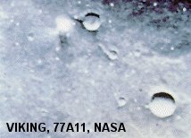
The possibility that such body of water once existed was first suggested by a number of features on images recorded by the Viking spacecraft in 1976. At that time become quite obvious the fact that parts of Martian surface, apart from the ice in the polar regions, contain permafrost, which occasionally melts producing water spouts, as was indicated by the image no. 77A11 on the right (cloud shape with shadow to the left of the upper crater). This image was first published in the NASA Activities newsletter, vol. 11, number 12 on Dec. 1980 by Dr. Leonard Martin of Lowell Observatory (click on the image for the link to the LAURA LEE SHOW interview with Vince DiPietro), and this led to his professional degradation making his discovery, to the public outside of the professional circles, unknown.
In press release on October 1, 1999, MSSS declared that the new high-resolution images, five to ten times better than those Viking has provided, shows no evidence of ancient oceans on Mars, but that the idea that Mars at one time had seas or oceans cannot not be ruled out.
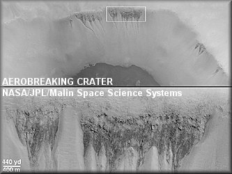
Than, on 22 June 2000, MSSS releases (click on the image to link to the MSSS site) that the first direct clue that there might be places on Mars where liquid water has seeped onto the surface in the geologically recent past came from a picture taken during the pre-mapping Orbit Insertion Phase of the mission at the end of December 1997, while the spacecraft was in the midst of aerobreaking maneuvers to put it into the circular orbit needed for the Mars surface Mapping. The image showed dark, V-shaped scars on the western wall of a 50 kilometer large impact crater in southern Noachis Terra at 65�S, 15�W. Scars appeared to be similar to seepage landforms present on Earth that form where springs emerge on a slope and water runs downhill.
In March 1999 MGS achieved its Mapping Orbit and in January 2000 a picture of 10 times higher resolution than the aerobreaking image was taken (above) of the possible seepage sites on the wall of the same crater, now called Aerobreaking crater. This new close-up shows that the dark V-shaped scars host many small channels of only a few meters across. These small channels run downslope, owing to the low atmospheric pressure evaporate and coalesce at the apex of each V.
According to MSSS, the gully landforms are usually found between latitudes 30� and 70� in both Martian hemispheres, on slopes facing away from mid-day sunlight, which keeps water running in them cooler, slowing down its evaporation. Furthermore it was said that the relationship to sunlight and latitude may indicate that ice plays a role in protecting the liquid water from evaporation until enough pressure builds for it to be released catastrophically down a slope.
Release concludes that the relative freshness of these features might indicate that some of them are still active today, meaning that liquid water may presently exist in some areas.
Nobody comments why the bottom of this crater is so dark as it were covered with ice or wet sand or how come that only NASA did not know that Mr. Steadman has the image of the whole Martian lake displayed on his website for years now
Source:
http://web.archive.org/web/20070203102755/http://www.cyberspaceorbit.com/steadlake.html
...
As far as water spouts are concerned there were lots of them near the Mars southern pole, at 121.91�W and 85.25�S, in October 1999, when this image was taken.
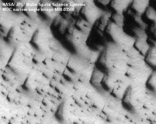
Image t is tilted 27 � to the right as is the source image linked to it. Details part of much larger area of obviously fluvial character, showing innumerable water spouts in light Martian wind.
From the physics is known that, at average atmospheric pressure on the Earth's surface (1 bar), water saturated with diluted kitchen salt (NaCl) can have freezing point as low as -21 �C. If right ratio of calcium chloride salt (CaCl) is used, freezing point goes down to -55 �C. At lower atmospheric pressure, for example equal to that which is average on Mars (0,006 bar) water evaporates at 0,04 �C.
Therefore, if water was present on Mars during long period of time, it is logical to presume that it has deeply penetrated every pore and cavity of the ground and that, over the time, has accumulated largest available content of various salts. Martian sea, as any other lowest level standing water or sea on any planet or moon, must have been rich with salts. Such water can remain liquid at very low temperature and still not evaporate at very low atmospheric pressure. Therefore the presence of liquid, salty water in the craters and canyons which are shielded form the Sun and whose upper surface is heated by the Sun could be expected.
...
More:
http://web.archive.org/web/20070203191016/http://www.deepspace4.com/pages/space/mars/mars.htm
---
Considernig that NASA is some 15 years late about this, instead to protect my company from destruction, I should have worked for them. Their money is 20x+ times better then local.
IZAKOVIC